|


[~][`] |
Lyell's "The Student's Elements of Geology" Chapter 5
Introduction:
The Student's Elements of Geology
Chapter 1: On the Different Classes of Rocks
Chapter
2:
Aqueous Rocks
Chapter 3:
Fossils in Strata
Chapter 4:
Consolidation of Strata and Petrifaction
Chapter 5:
Strata Above the Sea
Chapter 6:
Denudation
ELEVATION OF STRATA ABOVE
THE SEA; HORIZONTAL AND INCLINED STRATIFICATION
Why the Position of Marine Strata, above the
Level of the Sea, should be referred to the rising up of the Land, not to the
going down of the Sea. — Strata of Deep-sea and Shallow-water Origin alternate.
— Also Marine and Fresh-water Beds and old Land Surfaces. — Vertical, inclined,
and folded Strata. — Anticlinal and Synclinal Curves. — Theories to explain
Lateral Movements. — Creeps in Coal-mines. — Dip and Strike. — Structure of the
Jura. — Various Forms of Outcrop. — Synclinal Strata forming Ridges. —
Connection of Fracture and Flexure of Rocks. — Inverted Strata. — Faults
described. — Superficial Signs of the same obliterated by Denudation. — Great
Faults the Result of repeated Movements. — Arrangement and Direction of parallel
Folds of Strata. — Unconformability. — Overlapping Strata.
Land has been raised, not the Sea lowered.—It
has been already stated that the aqueous rocks containing marine fossils extend
over wide continental tracts, and are seen in mountain chains rising to great
heights above the level of the sea. Hence it follows, that what is now dry land
was once under water. But if we admit this conclusion, we must imagine, either
that there has been a general lowering of the waters of the ocean, or that the
solid rocks, once covered by water, have been raised up bodily out of the sea,
and have thus become dry land. The earlier geologists, finding themselves
reduced to this alternative, embraced the former opinion, assuming that the
ocean was originally universal, and had gradually sunk down to its actual level,
so that the present islands and continents were left dry. It seemed to them far
easier to conceive that the water had gone down, than that solid land had risen
upward into its present position. It was, however, impossible to invent any
satisfactory hypothesis to explain the disappearance of so enormous a body of
water throughout the globe, it being necessary to infer that the ocean had once
stood at whatever height marine shells might be detected. It moreover appeared
clear, as the science of geology advanced, that certain spaces on the globe had
been alternately sea, then land, then estuary, then sea again, and, lastly, once
more habitable land, having remained in each of these states for considerable
periods. In order to account for such phenomena without admitting any movement
of the land itself, we are required to imagine several retreats and returns of
the ocean; and even then our theory applies merely to cases where the marine
strata composing the dry land are horizontal, leaving unexplained those more
common instances where strata are inclined, curved, or placed on their edges,
and evidently not in the position in which they were first deposited.
Geologists, therefore, were at last compelled to
have recourse to the doctrine that the solid land has been repeatedly moved
upward or downward, so as permanently to change its position relatively to the
sea. There are several distinct grounds for preferring this conclusion. First,
it will account equally for the position of those elevated masses of marine
origin in which the stratification remains horizontal, and for those in which
the strata are disturbed, broken, inclined, or vertical. Secondly, it is
consistent with human experience that land should rise gradually in some places
and be depressed in others. Such changes have actually occurred in our own days,
and are now in progress, having been accompanied in some cases by violent
convulsions, while in others they have proceeded so insensibly as to have been
ascertainable only by the most careful scientific observations, made at
considerable intervals of time. On the other hand, there is no evidence from
human experience of a rising or lowering of the sea’s level in any region, and
the ocean can not be raised or depressed in one place without its level being
changed all over the globe.
[For a
different view see "A Possible Flood Mechanism" PRS]
These preliminary remarks will prepare the reader to
understand the great theoretical interest attached to all facts connected with
the position of strata, whether horizontal or inclined, curved or vertical.
Now the first and most simple appearance is where
strata of marine origin occur above the level of the sea in horizontal position.
Such are the strata which we meet with in the south of Sicily, filled with
shells for the most part of the same species as those now living in the
Mediterranean. Some of these rocks rise to the height of more than 2000 feet
above the sea. Other mountain masses might be mentioned, composed of horizontal
strata of high antiquity, which contain fossil remains of animals wholly
dissimilar from any now known to exist. In the south of Sweden, for example,
near Lake Wener, the beds of some of the oldest fossiliferous deposits, called
Silurian and Cambrian by geologists, occur in as level a position as if they had
recently formed part of the delta of a great river, and been left dry on the
retiring of the annual floods. Aqueous rocks of equal antiquity extend for
hundreds of miles over the lake-district of North America, and exhibit in like
manner a stratification nearly undisturbed. The Table Mountain at the Cape of
Good Hope is another example of highly elevated yet perfectly horizontal strata,
no less than 3500 feet in thickness, and consisting of sandstone of very ancient
date.
Instead of imagining that such fossiliferous
rocks were always at their present level, and that the sea was once high enough
to cover them, we suppose them to have constituted the ancient bed of the ocean,
and to have been afterwards uplifted to their present height. This idea, however
startling it may at first appear, is quite in accordance, as before stated, with
the analogy of changes now going on in certain regions of the globe. Thus, in
parts of Sweden, and the shores and islands of the Gulf of Bothnia, proofs have
been obtained that the land is experiencing, and has experienced for centuries,
a slow upheaving movement.*
It appears from the observations of Mr. Darwin and
others, that very extensive regions of the continent of South America have been
undergoing slow and gradual upheaval, by which the level plains of Patagonia,
covered with recent marine shells, and the Pampas of Buenos Ayres, have been
raised above the level of the sea. On the other hand, the gradual sinking of the
west coast of Greenland, for the space of more than 600 miles from north to
south, during the last four centuries, has been established by the observations
of a Danish naturalist, Dr. Pingel. And while these proofs of continental
elevation and subsidence, by slow and insensible movements, have been recently
brought to light, the evidence has been daily strengthened of continued changes
of level effected by violent convulsions in countries where earthquakes are
frequent. There the rocks are rent from time to time, and heaved up or thrown
down several feet at once, and disturbed in such a manner as to show how
entirely the original position of strata may be modified in the course of
centuries.
Mr. Darwin has also inferred that, in those seas
where circular coral islands and barrier reefs abound, there is a slow and
continued sinking of the submarine mountains on which the masses of coral are
based; while there are other areas of the South Sea where the land is on the
rise, and where coral has been upheaved far above the sea-level.
Alternations of Marine and Fresh-water Strata.—It
has been shown in the third chapter that there is such a difference between
land, fresh-water, and marine fossils as to enable the geologist to determine
whether particular groups of strata were formed at the bottom of the ocean or in
estuaries, rivers, or lakes. If surprise was at first created by the discovery
of marine corals and shells at the height of several miles above the sea-level,
the imagination was afterwards not less startled by observing that in the
successive strata composing the earth’s crust, especially if their total
thickness amounted to thousands of feet, they comprised in some parts formations
of shallow-sea as well as of deep-sea origin; also beds of brackish or even of
purely fresh-water formation, as well as vegetable matter or coal accumulated on
ancient land. In these cases we as frequently find fresh-water beds below a
marine set or shallow-water under those of deep-sea origin as the reverse. Thus,
if we bore an artesian well below London, we pass through a marine clay, and
there reach, at the depth of several hundred feet, a shallow-water and
fluviatile sand, beneath which comes the white chalk originally formed in a deep
sea. Or if we bore vertically through the chalk of the North Downs, we come,
after traversing marine chalky strata, upon a fresh-water formation many
hundreds of feet thick, called the Wealden, such as is seen in Kent and Surrey,
which is known in its turn to rest on purely marine beds. In like manner, in
various parts of Great Britain we sink vertical shafts through marine deposits
of great thickness, and come upon coal which was formed by the growth of plants
on an ancient land-surface sometimes hundreds of square miles in extent.
[Lyell assumes that the deposits were formed from material which has not
suffered major change of location. The same features might result from various
deposits being washed in by successive waves from different directions. The
scale of the waves which may have swept the globe following major meteorite
impacts has only recently been appreciated. PRS]
Vertical, Inclined, and Curved Strata.—It has
been stated that marine strata of different ages are sometimes found at a
considerable height above the sea, yet retaining their original horizontality;
but this state of things is quite exceptional. As a general rule, strata are
inclined or bent in such a manner as to imply that their original position has
been altered.
The most unequivocal evidence of such a change is
afforded by their standing up vertically, showing their edges, which is by no
means a rare phenomenon, especially in mountainous countries. Thus we find in
Scotland, on the southern skirts of the Grampians, beds of pudding-stone
alternating with thin layers of fine sand, all placed vertically to the horizon.
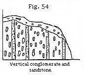
When Saussure first observed certain conglomerates in a similar position in the
Swiss Alps, he remarked that the pebbles, being for the most part of an oval
shape, had their longer axes parallel to the planes of stratification (see Fig.
54 on preceding page). From this he inferred that such strata must, at first,
have been horizontal, each oval pebble having settled at the bottom of the
water, with its flatter side parallel to the horizon, for the same reason that
an egg will not stand on either end if unsupported. Some few, indeed, of the
rounded stones in a conglomerate occasionally afford an exception to the above
rule, for the same reason that in a river’s bed, or on a shingle beach, some
pebbles rest on their ends or edges; these having been shoved against or between
other stones by a wave or current, so as to assume this position.
Anticlinal and Synclinal Curves.—Vertical
strata, when they can be traced continuously upward or downward for some depth,
are almost invariably seen to be parts of great curves, which may have a
diameter of a few yards, or of several miles. I shall first describe two curves
of considerable regularity, which occur in Forfarshire, extending over a country
twenty miles in breadth, from the foot of the Grampians to the sea near Arbroath.
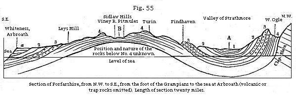
The mass of strata here shown may be 2000 feet in
thickness, consisting of red and white sandstone, and various coloured shales,
the beds being distinguishable into four principal groups, namely, No. 1, red
marl or shale; No. 2, red sandstone, used for building; No. 3, conglomerate; and
No. 4, grey paving-stone, and tile-stone, with green and reddish shale,
containing peculiar organic remains. A glance at the section will show that each
of the formations 2, 3, 4 are repeated thrice at the surface, twice with a
southerly, and once with a northerly
 inclination
or dip, and the beds in No. 1, which are nearly horizontal, are still
brought up twice by a slight curvature to the surface, once on each side of A.
Beginning at the north-west extremity, the tile-stones and conglomerates, No. 4
and No. 3, are vertical, and they generally form a ridge parallel to the
southern skirts of the Grampians. The superior strata, Nos. 2 and 1, become less
and less inclined on descending to the valley of Strathmore, where the strata,
having a concave bend, are said by geologists to lie in a “ trough" or “ basin."
Through the centre of this valley runs an imaginary line A, called technically a
“ synclinal line," where the beds, which are tilted in opposite directions, may
be supposed to meet. It is most important for the observer to mark such lines,
for he will perceive by the diagram that, in travelling from the north to the
centre of the basin, he is always passing from older to newer beds; whereas,
after crossing the line A, and pursuing his course in the same southerly
direction, he is continually leaving the newer, and advancing upon older strata.
All the deposits which he had before examined begin then to recur in reversed
order, until he arrives at the central axis of the Sidlaw hills, where the
strata are seen to form an arch, or saddle, having an anticlinal
line, B, in the centre. On passing this line, and continuing towards the S.E.,
the formations 4, 3, and 2, are again repeated, in the same relative order of
superposition, but with a southerly dip. At Whiteness (see Fig. 55) it will be
seen that the inclined strata are covered by a newer deposit, a, in
horizontal beds. These are composed of red conglomerate and sand, and are newer
than any of the groups, 1, 2, 3, 4, before described, and rest unconformably
upon strata of the sandstone group, No. 2. inclination
or dip, and the beds in No. 1, which are nearly horizontal, are still
brought up twice by a slight curvature to the surface, once on each side of A.
Beginning at the north-west extremity, the tile-stones and conglomerates, No. 4
and No. 3, are vertical, and they generally form a ridge parallel to the
southern skirts of the Grampians. The superior strata, Nos. 2 and 1, become less
and less inclined on descending to the valley of Strathmore, where the strata,
having a concave bend, are said by geologists to lie in a “ trough" or “ basin."
Through the centre of this valley runs an imaginary line A, called technically a
“ synclinal line," where the beds, which are tilted in opposite directions, may
be supposed to meet. It is most important for the observer to mark such lines,
for he will perceive by the diagram that, in travelling from the north to the
centre of the basin, he is always passing from older to newer beds; whereas,
after crossing the line A, and pursuing his course in the same southerly
direction, he is continually leaving the newer, and advancing upon older strata.
All the deposits which he had before examined begin then to recur in reversed
order, until he arrives at the central axis of the Sidlaw hills, where the
strata are seen to form an arch, or saddle, having an anticlinal
line, B, in the centre. On passing this line, and continuing towards the S.E.,
the formations 4, 3, and 2, are again repeated, in the same relative order of
superposition, but with a southerly dip. At Whiteness (see Fig. 55) it will be
seen that the inclined strata are covered by a newer deposit, a, in
horizontal beds. These are composed of red conglomerate and sand, and are newer
than any of the groups, 1, 2, 3, 4, before described, and rest unconformably
upon strata of the sandstone group, No. 2.
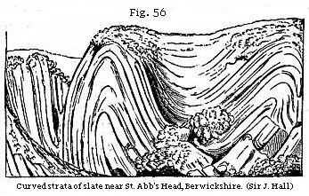
An example of curved strata, in which the
bends or convolutions of the rock are sharper and far more numerous within an
equal space, has been well described by Sir James Hall.**
It occurs near St. Abb’s Head, on the east coast of Scotland, where the roc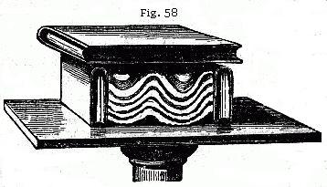 ks
consist principally of a bluish slate, having frequently a ripple-marked
surface. The undulations of the beds reach from the top to the bottom of cliffs
from 200 to 300 feet in height, and there are sixteen distinct bendings in the
course of about six miles, the curvatures being alternately concave and convex
upward. ks
consist principally of a bluish slate, having frequently a ripple-marked
surface. The undulations of the beds reach from the top to the bottom of cliffs
from 200 to 300 feet in height, and there are sixteen distinct bendings in the
course of about six miles, the curvatures being alternately concave and convex
upward.
Folding by Lateral Movement.—An experiment
was made by Sir James Hall, with a view of illustrating the manner in which such
strata, assuming them to have been originally horizontal, may have been forced
into their present position. A set of layers of clay were placed under a weight,
and their opposite ends pressed towards each other with such force as to cause
them to approach more nearly together. On the removal of the weight, the layers
of clay were found to be curved and folded, so as to bear a miniature
resemblance to the
 strata
in the cliffs. We must, however, bear in mind that in the natural section or
sea-cliff we only see the foldings imperfectly, one part being invisible beneath
the sea, and the other, or upper portion, being supposed to have been carried
away by denudation, or that action of water which will be explained in
the next chapter. The dark lines in the plan (Fig. 57) represent what is
actually seen of the strata in the line of cliff alluded to; the fainter lines,
that portion which is concealed beneath the sea-level, as also that which is
supposed to have once existed above the present surface. strata
in the cliffs. We must, however, bear in mind that in the natural section or
sea-cliff we only see the foldings imperfectly, one part being invisible beneath
the sea, and the other, or upper portion, being supposed to have been carried
away by denudation, or that action of water which will be explained in
the next chapter. The dark lines in the plan (Fig. 57) represent what is
actually seen of the strata in the line of cliff alluded to; the fainter lines,
that portion which is concealed beneath the sea-level, as also that which is
supposed to have once existed above the present surface.
We may still more easily illustrate the effects
which a lateral thrust might produce on flexible strata, by placing several
pieces of differently coloured cloths upon a table, and when they are spread out
horizontally, cover them with a book. Then apply other books to each end, and
force them towards each other. The folding of the cloths (see Fig. 58) will
imitate those of the bent strata; the incumbent book being slightly lifted up,
and no longer touching the two volumes on which it rested before, because it is
supported by the tops of the anticlinal ridges formed by the curved cloths. In
like manner there can be no doubt that the squeezed strata, although laterally
condensed and more closely packed, are yet elongated and made to rise upward, in
a direction perpendicular to the pressure.
Whether the analogous flexures in stratified rocks
have really been due to similar sideway movements is a question which we can not
decide by reference to our own observation. Our inability to explain the nature
of the process is, perhaps, not simply owing to the inaccessibility of the
subterranean regions where the mechanical force is exerted, but to the extreme
slowness of the movement. The changes may sometimes be due to variation in the
temperature of mountain masses of rock causing them, while still solid, to
expand or contract; or melting them, and then again cooling them and allowing
them to crystallise. If such be the case, we have scarcely more reason to expect
to witness the operation of the process within the limited periods of our
scientific observation than to see the swelling of the roots of a tree, by
which, in the course of years, a wall of solid masonry may be lifted up, rent or
thrown down. In both instances the force may be irresistible, but though
adequate, it need not be visible by us, provided the time required for its
development be very great. The lateral pressure arising from the unequal
expansion of rocks by heat may cause one mass lying in the same horizontal plane
gradually to occupy a larger space, so as to press upon another rock, which, if
flexible, may be squeezed into a bent and folded form. It will also appear, when
the volcanic and granitic rocks are described, that some of them have, when
melted in the interior of the earth’s crust, been injected forcibly into
fissures, and after the solidification of such intruded matter, other sets of
rents, crossing the first, have been formed and in their turn filled by melted
rock. Such repeated injections imply a stretching, and often upheaval, of the
whole mass.
We also know, especially by the study of regions
liable to earthquakes, that there are causes at work in the interior of the
earth capable of producing a sinking in of the ground, sometimes very local, but
often extending over a wide area. The continuance of such a downward movement,
especially if partial and confined to linear areas, may produce regular folds in
the strata.
[Folds can have a very tight radius of curvature. It would be expected that
rock could not curve so tightly without breaking. It is far easier to see how
wet sediments could fold, and later harden into rock. Such observations suggest
that a vast thickness of newly deposited, unconsolidated sediment was involved.
For the sediments to remain unconsolidated throughout this folding must have
occurred quickly. PRS]
Creeps in Coal-mines.—The “creeps,” as
they are called in coal-mines, afford an excellent illustration of this
fact.--First, it may be stated generally, that the excavation of coal at a
considerable depth causes the mass of overlying strata to sink down bodily, even
when props are left to support the roof of the mine. “In Yorkshire,” says Mr.
Buddle, “three distinct subsidences were perceptible at the surface, after the
clearing out of three seams of coal below, and innumerable vertical cracks were
caused in the incumbent mass of sandstone and shale which thus settled down.”***
The exact amount of depression in these cases can only be accurately measured
where water accumulates on the surface, or a railway traverses a coal-field.
When a bed of coal is worked out, pillars or
rectangular masses of coal are left at intervals as props to support the roof,
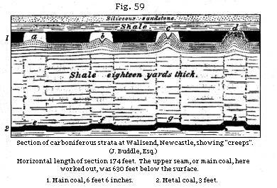
and protect the colliers. Thus in Fig. 59, representing a section at Wallsend,
Newcastle, the galleries which have been excavated are represented by the white
spaces a, b, while the adjoining dark portions are parts of the original
coal seam left as props, beds of sandy clay or shale constituting the floor of
the mine. When the props have been reduced in size, they are pressed down by the
weight of overlying rocks (no less than 630 feet thick) upon the shale below,
which is thereby squeezed and forced up into the open spaces.
Now it might have been expected that, instead of the
floor rising up, the ceiling would sink down, and this effect, called a
“thrust,” does, in fact, take place where the pavement is more solid than the
roof. But it usually happens, in coal-mines, that the roof is composed of hard
shale, or occasionally of sandstone, more unyielding than the foundation, which
often consists of clay. Even where the argillaceous substrata are hard at first,
they soon become softened and reduced to a plastic state when exposed to the
contact of air and water in the floor of a mine.
The first symptom of a “creep,” says Mr. Buddle, is
a slight curvature at the bottom of each gallery, as at a, Fig. 59: then
the pavement, continuing to rise, begins to open with a longitudinal crack, as
at b; then the points of the fractured ridge reach the roof, as at c;
and, lastly, the upraised beds close up the whole gallery, and the broken
portions of the ridge are reunited and flattened at the top, exhibiting the
flexure seen at d. Meanwhile the coal in the props has become crushed and
cracked by pressure. It is also found that below the creeps a, b, c, d,
an inferior stratum, called the “metal coal,” which is 3 feet thick, has been
fractured at the points e, f, g, h, and has risen, so as to prove that
the upward movement, caused by the working out of the “main coal,” has been
propagated through a thickness of 54 feet of argillaceous beds, which intervene
between the two coal-seams. This same displacement has also been traced downward
more than 150 feet below the metal coal, but it grows continually less and less
until it becomes imperceptible.
 No
part of the process above described is more deserving of our notice than the
slowness with which the change in the arrangement of the beds is brought about.
Days, months, or even years, will sometimes elapse between the first bending of
the pavement and the time of its reaching the roof. Where the movement has been
most rapid, the curvature of the beds is most regular, and the reunion of the
fractured ends most complete; whereas the signs of displacement or violence are
greatest in those creeps which have required months or years for their entire
accomplishment. Hence we may conclude that similar changes may have been wrought
on a larger scale in the earth’s crust by partial and No
part of the process above described is more deserving of our notice than the
slowness with which the change in the arrangement of the beds is brought about.
Days, months, or even years, will sometimes elapse between the first bending of
the pavement and the time of its reaching the roof. Where the movement has been
most rapid, the curvature of the beds is most regular, and the reunion of the
fractured ends most complete; whereas the signs of displacement or violence are
greatest in those creeps which have required months or years for their entire
accomplishment. Hence we may conclude that similar changes may have been wrought
on a larger scale in the earth’s crust by partial and
 gradual
subsidences, especially where the ground has been undermined throughout long
periods of time; and we must be on our guard against inferring sudden violence,
simply because the distortion of the beds is excessive. gradual
subsidences, especially where the ground has been undermined throughout long
periods of time; and we must be on our guard against inferring sudden violence,
simply because the distortion of the beds is excessive.
Engineers are familiar with the fact that when they
raise the level of a railway by heaping stone or gravel on a foundation of
marsh, quicksand, or other yielding formation, the new mound often sinks for a
time as fast as they attempt to elevate it; when they have persevered so as to
overcome this difficulty, they frequently find that some of the adjoining
flexible ground has risen up in one or more parallel arches or folds, showing
that the vertical pressure of the sinking materials has given rise to a lateral
folding movement.
In like manner, in the interior of the earth, the
solid parts of the earth’s crust may sometimes, as before mentioned, be made to
expand by heat, or may be pressed by the force of steam against flexible strata
loaded with a great weight of incumbent rocks. In this case the yielding mass,
squeezed, but unable to overcome the resistance which it meets with in a
vertical direction, may be gradually relieved by lateral folding.
Dip and Strike.—In describing the manner in
which strata depart from their original horizontality, some technical terms,
such as “dip” and “strike,” “anticlinal” and “synclinal” line or axis, are used
by geologists. I shall now proceed to explain some of these to the student. If a
stratum or bed of rock, instead of being quite level, be inclined to one side,
it is said to dip; the point of the compass to which it is inclined is
called the point of dip,
 and
the degree of deviation from a level or horizontal line is called the amount
of dip, or the angle of dip. Thus, in the annexed diagram (Fig. 60),
a series of strata are inclined, and they dip to the north at an angle of
forty-five degrees. The strike, or line of bearing, is the
prolongation or extension of the strata in a direction at right angles to
the dip; and hence it is sometimes called the direction of the strata.
Thus, in the above instance of strata dipping to the north, their strike must
necessarily be east and west. We have borrowed the word from the German
geologists, streichen signifying to extend, to have a certain direction.
Dip and strike may be aptly illustrated by a row of houses running east and
west, the long ridge of the roof representing the strike of the stratum of
slates, which dip on one side to the north, and on the other to the south. and
the degree of deviation from a level or horizontal line is called the amount
of dip, or the angle of dip. Thus, in the annexed diagram (Fig. 60),
a series of strata are inclined, and they dip to the north at an angle of
forty-five degrees. The strike, or line of bearing, is the
prolongation or extension of the strata in a direction at right angles to
the dip; and hence it is sometimes called the direction of the strata.
Thus, in the above instance of strata dipping to the north, their strike must
necessarily be east and west. We have borrowed the word from the German
geologists, streichen signifying to extend, to have a certain direction.
Dip and strike may be aptly illustrated by a row of houses running east and
west, the long ridge of the roof representing the strike of the stratum of
slates, which dip on one side to the north, and on the other to the south.
A stratum which is horizontal, or quite level in all
directions, has neither dip nor strike.
It is always important for the geologist, who is
endeavouring to comprehend the structure of a country, to learn how the beds dip
in every part of the district; but it requires some practice to avoid being
occasionally deceived, both as to the point of dip and the amount of it.
If the upper surface of a hard stony stratum be
uncovered, whether artificially in a quarry, or by waves at the foot of a cliff,
it is easy to determine towards what point of the compass the slope is steepest,
or in what direction water would flow if poured upon it. This is the true dip.
But the edges of highly inclined strata may give rise to perfectly horizontal
lines in the face of a vertical cliff, if the observer see the strata in the
line of the strike, the dip being inward from the face of the cliff. If,
however, we come to a break in the cliff, which exhibits a section exactly at
right angles to the line of the strike, we are then able to ascertain the true
dip. In the drawing (Fig. 61), we may suppose a headland, one side of which
faces to the north, where the beds would appear perfectly horizontal to a person
in the boat; while in the other side facing the west, the true dip would be seen
by the person on shore to be at an angle of 40°. If, therefore, our observations
are confined to a vertical precipice facing in one direction, we must endeavour
to find a ledge or portion of the plane of one of the beds projecting beyond the
others, in order to ascertain the true dip.
If not provided with a clinometer, a most useful
instrument, when it is of consequence to determine with precision the
inclination of the strata, the observer may measure the angle within a few
degrees by standing exactly opposite to a cliff where the true dip is exhibited,
holding the hands immediately before the eyes, and placing the fingers of one in
a perpendicular, and of the other in a horizontal position, as in Fig. 62. It is
thus easy to discover whether the lines of the inclined beds bisect the angle of
90°, formed by the meeting of the hands, so as to give an angle of 45°, or
whether it would divide the space into two equal or unequal portions. You have
only to change hands to get the line of dip on the upper side of the horizontal
hand.
It has been already seen, in describing the
curved strata on the east coast of Scotland, in Forfarshire and Berwickshire,
that a series of concave and convex bendings are occasionally repeated several
times. These usually form part of a series of parallel waves of strata, which
are prolonged in the same direction, throughout a considerable extent of
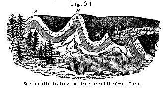
country. Thus, for example, in the Swiss Jura, that lofty chain of mountains has
been proved to consist of many parallel ridges, with intervening longitudinal
valleys, as in Fig. 63, the ridges being formed by curved fossiliferous strata,
of which the nature and dip are occasionally displayed in deep transverse
gorges, called “cluses,” caused by fractures at right angles to the direction of
the chain.pages/****
Now let us suppose these ridges and parallel valleys to run north and south, we
should then say that the strike of the beds is north and south, and the
dip east and west. Lines drawn along the summits of the ridges, A, B,
would be anticlinal lines, and one following the bottom of the adjoining valleys
a synclinal line.
 Outcrop
of Strata.—It will be observed that some of these ridges, A, B, are unbroken
on the summit, whereas one of them, C, has been fractured along the line of
strike, and a portion of it carried away by denudation, so that the ridges of
the beds in the formations a, b, c come out to the day, or, as the miners
say, crop out, on the sides of a valley. The ground-plan of such a
denuded ridge as C, as given in a geological map, may be expressed by the
diagram, Fig. 64, and the cross-section of the same by Fig. 65. The line D E,
Fig. 64, is the anticlinal line, on each side of which the dip is in opposite
directions, as expressed by the arrows. The emergence of strata at the surface
is called by miners their outcrop, or basset. Outcrop
of Strata.—It will be observed that some of these ridges, A, B, are unbroken
on the summit, whereas one of them, C, has been fractured along the line of
strike, and a portion of it carried away by denudation, so that the ridges of
the beds in the formations a, b, c come out to the day, or, as the miners
say, crop out, on the sides of a valley. The ground-plan of such a
denuded ridge as C, as given in a geological map, may be expressed by the
diagram, Fig. 64, and the cross-section of the same by Fig. 65. The line D E,
Fig. 64, is the anticlinal line, on each side of which the dip is in opposite
directions, as expressed by the arrows. The emergence of strata at the surface
is called by miners their outcrop, or basset.
If, instead of being folded into parallel ridges,
the beds form a boss or dome-shaped protuberance, and if we suppose the summit
of the dome carried off, the ground-plan would exhibit the edges of the strata
forming a succession of circles, or ellipses, round a common centre. These
circles are the lines of strike, and the dip being always at right angles is
inclined in the course of the circuit to every point of the compass,
constituting what is termed a quâ-quâversal dip--that is, turning every way.
There are endless variations in the figures
described by the basset-edges of the strata, according to the different
inclination of the beds, and the mode in which they happen to have been denuded.
One of the simplest rules, with which every geologist should be acquainted,
relates to the V-like form of the beds as they crop out in an ordinary valley.
First, if the strata be horizontal, the V-like form will be also on a level, and
the newest strata will appear at the greatest heights.
Secondly, if the beds be inclined and intersected by
a valley sloping in the same direction, and the dip of the beds be less steep
than the slope of the valley, then the V’s, as they are often termed by miners,
will point upward (see Fig. 66), those formed by the newer beds appearing in a
superior position, and extending highest up the valley, as A is seen above B.
Thirdly, if the dip of the beds be steeper than the
slope of the valley, then the V’s will point downward (see Fig. 67), and those
formed of the older beds will now appear uppermost, as B appears above A.
Fourthly, in every case where th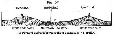 e
strata dip in a contrary direction to the slope of the valley, whatever be the
angle of inclination, the newer beds will appear the highest, as in the first
and second cases. This is shown by the drawing (Fig. 68), which exhibits strata
rising at an angle of 20°, and crossed by a valley, which declines in an
opposite direction at 20°. e
strata dip in a contrary direction to the slope of the valley, whatever be the
angle of inclination, the newer beds will appear the highest, as in the first
and second cases. This is shown by the drawing (Fig. 68), which exhibits strata
rising at an angle of 20°, and crossed by a valley, which declines in an
opposite direction at 20°.
These rules may often be of great practical
utility; for the different degrees of dip occurring in the two cases represented
in Figs. 66 and 67 may occasionally be encountered in following the same line of
flexure at points a few miles distant from each other. A miner unacquainted with
the rule, who had first explored the valley
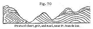 Fig.
66, may have sunk a vertical shaft below the coal-seam A, until he reached the
inferior bed, B. He might then pass to the valley, Fig. 67, and discovering
there also the outcrop of two coal-seams, might begin his workings in the
uppermost in the expectation of coming down to the other bed A, which would be
observed cropping out lower down the valley. But a glance at the section will
demonstrate the futility of such hopes.pages/****
* Fig.
66, may have sunk a vertical shaft below the coal-seam A, until he reached the
inferior bed, B. He might then pass to the valley, Fig. 67, and discovering
there also the outcrop of two coal-seams, might begin his workings in the
uppermost in the expectation of coming down to the other bed A, which would be
observed cropping out lower down the valley. But a glance at the section will
demonstrate the futility of such hopes.pages/****
*
Synclinal Strata forming Ridges.—Although in
many cases an anticlinal axis forms a ridge, and a synclinal axis a valley, as
in A B, Fig. 63, yet this can by no means be laid down as a general rule, as the
beds very often slope inward from either side of a mountain, as at a, b,
Fig. 69, while in the intervening valley, c, they slope upward, forming
an arch.
It would be natural to expect the fracture of
solid rocks to take place chiefly where the bending of the strata has been
sharpest, and such rending may produce ravines giving access to running water
and exposing the surface to atmospheric waste. The entire absence, however, of
such cracks at points where the strain must have been greatest, as at a,
Fig. 63, is often very remarkable, and not always easy of explanation. We must
imagine that many strata of limestone, chert, and other rocks which are now
brittle, were pliant when bent into their present position. They may have owed
their flexibility in part to the fluid matter which they contained in their
minute pores, as before described
p. 62 and in
part to the permeation of sea-water while they were yet submerged.
At the western extremity of the Pyrenees, great
curvatures of the strata are seen in the sea-cliffs, where the rocks consist of
marl, grit, and chert. At certain points, as at a, Fig. 70, some of the
bendings of the flinty chert are so sharp that specimens might be broken off
well fitted to serve as ridge-tiles on the roof of a house. Although this chert
could not have been brittle as now, when first folded into this shape, it
presents, nevertheless, here and there, at the points of greatest flexure, small
cracks, which show that it was solid, and not wholly incapable of breaking at
the period of its displacement. The numerous rents alluded to are not empty, but
filled with chalcedony and quartz.
Between San Caterina and Castrogiovanni, in Sicily,
bent and undulating gypseous marls occur, with here and there thin beds of solid
gypsum interstratified. Sometimes these solid layers have been broken into
detached fragments, still preserving their sharp edges (g, g, Fig. 71),
while the continuity of the more pliable and ductile
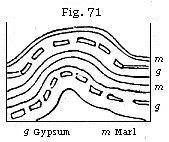 marls,
m, m, has not been interrupted. marls,
m, m, has not been interrupted.
We have already explained, Fig. 69, that stratified
rocks have usually their strata bent into parallel folds forming anticlinal and
synclinal axes, a group of several of these folds having often been subjected to
a common movement, and having acquired a uniform strike or direction. In some
disturbed regions these folds have been doubled back upon themselves in such a
manner that it is often difficult for an experienced geologist to determine
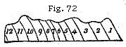
correctly the relative age of the beds by superposition. Thus, if we meet with
the strata seen in the section, Fig. 72, we should naturally suppose that there
were twelve distinct beds, or sets of beds, No. 1 being the newest, and No. 12
the oldest of the series. But this section may perhaps exhibit merely six beds,
which have been folded in the manner seen in Fig. 73, so that each of them is
twice repeated, the position of one half being reversed, and part of No. 1,
originally the uppermost, having now become the lowest of the series.
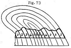 These
phenomena are observable on a magnificent scale in certain regions in
Switzerland, in precipices often more than 2000 feet in perpendicular height,
and there are flexures not inferior in dimensions in the Pyrenees. The upper
part of the curves seen in this diagram, Fig. 73, and expressed in fainter
lines, has been removed by what is called denudation, to be afterwards
explained. These
phenomena are observable on a magnificent scale in certain regions in
Switzerland, in precipices often more than 2000 feet in perpendicular height,
and there are flexures not inferior in dimensions in the Pyrenees. The upper
part of the curves seen in this diagram, Fig. 73, and expressed in fainter
lines, has been removed by what is called denudation, to be afterwards
explained.
Fractures of the Strata and Faults.—Numerous
rents may often be seen in rocks which appear to have been simply broken, the
fractured parts still remaining in contact; but we often find a fissure, several
inches or yards wide, intervening between the disunited portions. These fissures
are usually filled with fine earth and sand, or with angular fragments of stone,
evidently derived from the fracture of the contiguous rocks.
 The
face of each wall of the fissure is often beautifully polished, as if glazed,
striated, or scored with parallel furrows and ridges, such as would be produced
by the continued rubbing together of surfaces of unequal hardness. These
polished surfaces are called by miners “slickensides.” It is supposed that the
lines of the striæ indicate the direction in which the rocks were moved. During
one of the minor earthquakes in Chili, in 1840, the brick walls of a building
were rent vertically in several places, and made to vibrate for several minutes
during each shock, after which they remained uninjured, and without any opening,
although the line of each crack was still visible. When all movement had ceased,
there were seen on the floor of the house, at the bottom of each rent, small
heaps of fine brick-dust, evidently produced by trituration. The
face of each wall of the fissure is often beautifully polished, as if glazed,
striated, or scored with parallel furrows and ridges, such as would be produced
by the continued rubbing together of surfaces of unequal hardness. These
polished surfaces are called by miners “slickensides.” It is supposed that the
lines of the striæ indicate the direction in which the rocks were moved. During
one of the minor earthquakes in Chili, in 1840, the brick walls of a building
were rent vertically in several places, and made to vibrate for several minutes
during each shock, after which they remained uninjured, and without any opening,
although the line of each crack was still visible. When all movement had ceased,
there were seen on the floor of the house, at the bottom of each rent, small
heaps of fine brick-dust, evidently produced by trituration.

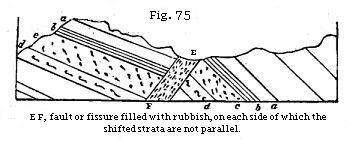
It is not uncommon to find the mass of rock on
one side of a fissure thrown up above or down below the mass with which it was
once in contact on the other side. “This mode of displacement is called a fault,
shift, slip, or throw.” “The miner,” says Playfair, describing a fault, “is
often perplexed, in his subterranean journey, by a derangement in the strata,
which changes at once all those lines and bearings which had hitherto directed
his course. When his mine reaches a certain plane, which is sometimes
perpendicular, as in A B, Fig. 74, sometimes oblique to the horizon (as in C D,
ibid.), he finds the beds of rock broken asunder, those on the one side of the
plane having changed their place, by sliding in a particular direction along the
face of the others. In this motion they have sometimes preserved their
parallelism, as in Fig. 74, so that the strata on each side of faults A B, C D,
continue parallel to one another; in other cases, the strata on each side are
inclined, as in a, b, c, d (Fig. 75), though their identity is still to
be recognised by their possessing the same thickness and the same internal
characters.”pages/****
**
In Coalbrook Dale, says Mr. Prestwich†
, deposits of sandstone, shale, and coal, several thousand feet thick, and
occupying an area of many miles, have been shivered into fragments, and the
broken remnants have been placed in very discordant positions, often at levels
differing several hundred feet from each other. The sides of the faults, when
perpendicular, are commonly several yards apart, and are sometimes as much as 50
yards asunder, the interval being filled with broken débris of the
strata. In following the course of the same fault it is sometimes found to
produce in different places very unequal changes of level, the amount of shift
being in one place 300, and in another 700 feet, which arises from the union of
two or more faults. In other words, the disjointed strata have in certain
districts been subjected to renewed movements, which they have not suffered
elsewhere.
We may occasionally see exact counterparts of these
slips, on a small scale, in pits of loose sand and gravel, many of which have
doubtless been caused by the drying and shrinking of argillaceous and other
beds, slight subsidences having taken place from failure of support. Sometimes,
however, even these small slips may have been produced during earthquakes; for
land has been moved, and its level, relatively to the sea, considerably altered,
within the period when much of the alluvial sand and gravel now covering the
surface of continents was deposited.
I have already stated that a geologist must be on
his guard, in a region of disturbed strata, against inferring repeated
alternations of rocks, when, in fact, the same strata, once continuous, have
been bent round so as to recur in the same section, and with the same dip. A
similar mistake has often been occasioned by a series of faults.
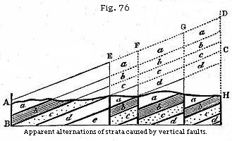
If, for example, the dark line A H (Fig. 76)
represent the surface of a country on which the strata a, b, c frequently
crop out, an observer who is proceeding from H to A might at first imagine that
at every step he was approaching new strata, whereas the repetition of the same
beds has been caused by vertical faults, or downthrows. Thus, suppose the
original mass, A, B, C, D, to have been a set of uniformly inclined strata, and
that the different masses under E F, F G, and G D sank down successively, so as
to leave vacant the spaces marked in the diagram by dotted lines, and to occupy
those marked by the continuous lines, then let denudation take place along the
line A H, so that the protruding masses indicated by the fainter lines are swept
away--a miner, who has not discovered the faults, finding the mass a,
which we will suppose to be a bed of coal four times repeated, might hope to
find four beds, workable to an indefinite depth, but first, on arriving at the
fault G, he is stopped suddenly in his workings, for he comes partly upon the
shale b, and partly on the sandstone c; the same result awaits him
at the fault F, and on reaching E he is again stopped by a wall composed of the
rock d.
The very different levels at which the
separated parts of the same strata are found on the different sides of the
fissure, in some faults, is truly astonishing. One of the most celebrated in
England is that called the “ninety-fathom dike,” in the coal-field of Newcastle.
This name has been given to it, because the same beds are ninety fathoms (540
feet) lower on the northern than they are on the southern side. The fissure has
been filled by a body of sand, which is now in the state of sandstone, and is
called the dike, which is sometimes very narrow, but in other places more than
twenty yards wide.pages/****
***
The walls of the fissure are scored by grooves, such as would have been produced
if the broken ends of the rock had been rubbed along the plane of the fault.††
In the Tynedale and Craven faults, in the north of England, the vertical
displacement is still greater, and the fracture has extended in a horizontal
direction for a distance of thirty miles or more.
Great Faults the Result of Repeated Movements.—It
must not, however, be supposed that faults generally consist of single linear
rents; there are usually a number of faults springing off from the main one, and
sometimes a long strip of country seems broken up into fragments by sets of
parallel and connecting transverse faults. Oftentimes a great line of fault has
been repeated, or the movements have been continued through successive periods,
so that, newer deposits having covered the old line of displacement, the strata
both newer and older have given way along the old line of fracture. Some
geologists have considered it necessary to imagine that the upward or downward
movement in these cases was accomplished at a single stroke, and not by a series
of sudden but interrupted movements. They appear to have derived this idea from
a notion that the grooved walls have merely been rubbed in one direction, which
is far from being a constant phenomenon. Not only are some sets of striæ not
parallel to others, but the clay and rubbish between the walls, when squeezed or
rubbed, have been streaked in different directions, the grooves which the harder
minerals have impressed on the softer being frequently curved and irregular.
The usual absence of protruding masses of rock
forming precipices or ridges along the lines of great faults has already been
alluded to in explaining Fig. 76, p. 89, and the same remarkable fact is well
exemplified in every coal-field which has been extensively worked. It is in such
districts that the former relation of the beds which have been shifted is
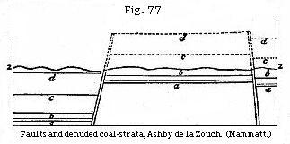
determinable with great accuracy. Thus in the coal-field of Ashby de la Zouch,
in Leicestershire (see Fig. 77), a fault occurs, on one side of which the
coal-beds a, b, c, d must once have risen to the height of 500 feet above
the corresponding beds on the other side. But the uplifted strata do not stand
up 500 feet above the general surface; on the contrary, the outline of the
country, as expressed by the line z z, is uniformly undulating, without
any break, and the mass indicated by the dotted outline must have been washed
away.pages/****
pages/****
The student may refer to Mr. Hull’s
measurement of faults, observed in the Lancashire coal-field, where the vertical
displacement has amounted to thousands of feet, and yet where all the
superficial inequalities which must have resulted from such movements have been
obliterated by subsequent denudation. In the same memoir proofs are afforded of
there having been two periods of vertical movement in the same fault--one, for
example, before, and another after, the Triassic epoch.†††
The shifting of the beds by faults is often
intimately connected with those same foldings which constitute the anti-clinal
and synclinal axes before alluded to, and there is no doubt that the
subterranean causes of both forms of disturbance are to a great extent the same.
A fault in Virginia, believed to imply a displacement of several thousand feet,
has been traced for more than eighty miles in the same direction as the foldings
of the Appalachian chain.pages/****
pages/****
*
An hypothesis which attributes such a change of position to a succession of
movements, is far preferable to any theory which assumes each fault to have been
accomplished by a single upcast or downthrow of several thousand feet. For we
know that there are operations now in progress, at great depths in the interior
of the earth, by which both large and small tracts of ground are made to rise
above and sink below their former level, some slowly and insensibly, others
suddenly and by starts, a few feet or yards at a time; whereas there are no
grounds for believing that, during the last 3000 years at least, any regions
have been either upheaved or depressed, at a single stroke, to the amount of
several hundred, much less several thousand feet.
[Such a
movement would not fit Lyell's uniformity principle, but it would fit well with
the catastrophic events accompanying the breaking up of the fountains of the
deep. PRS]
It is certainly not easy to understand how in the
subterranean regions one mass of solid rock should have been folded up by a
continued series of movements, while another mass in contact, or only separated
by a line of fissure, has remained stationary or has perhaps subsided. But every
volcano, by the intermittent action of the steam, gases, and lava evolved during
an eruption, helps us to form some idea of the manner in which such operations
take place. For eruptions are repeated at uncertain intervals throughout the
whole or a large part of a geological period, some of the surrounding and
contiguous districts remaining quite undisturbed. And in most of the instances
with which we are best acquainted the emission of lava, scoria, and steam is
accompanied by the uplifting of the solid crust. Thus in Vesuvius, Etna, the
Madeiras, the Canary Islands, and the Azores there is evidence of marine
deposits of recent and tertiary date having been elevated to the height of a
thousand feet, and sometimes more, since the commencement of the volcanic
explosions. There is, moreover, a general tendency in contemporaneous volcanic
vents to affect a linear arrangement, extending in some instances, as in the
Andes or the Indian Archipelago, to distances equalling half the circumference
of the globe. Where volcanic heat, therefore, operates at such a depth as not to
obtain vent at the surface, in the form of an eruption, it may nevertheless be
conceived to give rise to upheavals, foldings, and faults in certain linear
tracts. And marine denudation, to be treated of in the next chapter, will help
us to understand why that which should be the protruding portion of the faulted
rocks is missing at the surface.
Arrangement and Direction of Parallel Folds of
Strata.—The possible causes of the folding of strata by lateral movements
have been considered in a former part of this chapter. No European chain of
mountains affords so remarkable an illustration of the persistency of such
flexures for a great distance as the Appalachians before alluded to, and none
has been studied and described by many good observers with more accuracy. The
chain extends from north to south, or rather N.N.E. to S.S.W., for nearly 1500
miles, with a breadth of 50 miles, throughout which the Palæozoic strata have
been so bent as to form a series of parallel anticlinal and synclinal ridges and
troughs, comprising usually three or four principal and many smaller plications,
some of them forming broad and gentle arches, others narrower and steeper ones,
while some, where the bending has been greatest, have the position of their beds
inverted, as before shown in Fig. 73, p. 87.
The strike of the parallel ridges, after continuing
in a straight line for many hundred miles, is then found to vary for a more
limited distance as much as 30°, the folds wheeling round together in the new
direction and continuing to be parallel, as if they had all obeyed the same
movement. The date of the movements by which the great flexures were brought
about must, of course, be subsequent to the formation of the uppermost part of
the coal or the newest of the bent rocks, but the disturbance must have ceased
before the Triassic strata were deposited on the denuded edges of the folded
beds.
The manner in which the numerous parallel folds, all
simultaneously formed, assume a new direction common to the whole of them, and
sometimes varying at an angle of 30° from the normal strike of the chain, shows
what deviation from an otherwise uniform strike of the beds may be experienced
when the geographical area through which they are traced is on so vast a scale.
The disturbances in the case here adverted to
occurred between the Carboniferous period and that of the Trias, and this
interval is so vast that they may have occupied a great lapse of time, during
which their parallelism was always preserved. But, as a rule, wherever after a
long geological interval the recurrence of lateral movements gives rise to a new
set of folds, the strike of these last is different. Thus, for example, Mr. Hull
has pointed out that three principal lines of disturbance, all later than the
Carboniferous period, have affected the stratified rocks of Lancashire. The
first of these, having an E.N.E. direction, took place at the close of the
Carboniferous period. The next, running north and south, at the close of the
Permian, and the third, having a N.N.W. direction, at the close of the Jurassic
period.pages/****
pages/****
**

Unconformability of Strata.— Strata are said
to be unconformable when one series is so placed over another that the planes of
the superior repose on the edges of the inferior (see Fig. 78). In this case it
is evident that a period had elapsed between the production of the two sets of
strata, and that, during this interval, the older series had been tilted and
disturbed. Afterwards the upper series was thrown down in horizontal strata upon
it. If these superior beds, d, d, Fig. 78, are also inclined, it is plain
that the lower strata a, a, have been twice displaced; first, before the
deposition of the newer beds, d, d, and a second time when these same
strata were upraised out of the sea, and thrown slightly out of the horizontal
position.
It often happens that in the interval between the
deposition of two sets of unconformable strata, the inferior rock has not only
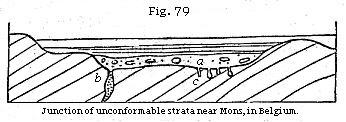
been denuded, but drilled by perforating shells. Thus, for example, at Autreppe
and Gusigny, near Mons, beds of an ancient (primary or palæozoic) limestone,
highly inclined, and often bent, are covered with horizontal strata of greenish
and whitish marls of the Cretaceous formation. The lowest, and therefore the
oldest, bed of the horizontal series is usually the sand and conglomerate, a,
in which are rounded fragments of stone, from an inch to two feet in diameter.
These fragments have often adhering shells attached to them, and have been bored
by perforating mollusca. The solid surface of the inferior limestone has also
been bored, so as to exhibit cylindrical and pear-shaped cavities, as at c,
the work of saxicavous mollusca; and many rents, as at b, which descend
several feet or yards into the limestone, have been filled with sand and shells,
similar to those in the stratum a.
Overlapping Strata.—Strata are said to
overlap when an upper bed extends beyond the limits of a lower one. This may be
produced in various ways; as, for example, when alterations of physical
geography cause the arms of a river or channels of discharge to vary, so that
sediment brought down is deposited over a wider area than before, or when the
sea-bottom has been raised up and again depressed without disturbing the
horizontal position of the strata. In this case the newer strata may rest for
the most part conformably on the older, but, extending farther, pass over their
edges. Every intermediate state between unconformable and over-lapping beds may
occur, because there may be every gradation between a slight derangement of
position, and a considerable disturbance and denudation of the older formation
before the newer beds come on.
Notes
1 See
"Principles of Geology," 1867, p. 314.
2 Edin.
Trans., vol. vii, pl. 3.
3 Proceedings
of Geol. Soc., vol. iii, p. 148.
4 Thurmann,
“Essai sur les Soulèvemens Jurassiques de Porrentruy,” Paris, 1832.
5 I am
indebted to the kindness of T. Sopwith, Esq., for three models which I have
copied in the above diagrams; but the beginner may find it by no means easy to
understand such copies, although, if he were to examine and handle the
originals, turning them about in different ways, he would at once comprehend
their meaning, as well as the import of others far more complicated, which the
same engineer has constructed to illustrate faults.
6 Playfair, Illust. of Hutt. Theory, § 42.
7 Geol. Trans., second series. vol. v, p. 452.
8 Conybeare and Phillips Outlines, etc., p. 376.
9 Phillips, Geology, Lardner’s Cyclop., p. 41.
10 See
Mammatt’s Geological Facts, etc., p. 90 and plate.
11 Hull, Quart. Geol.
Journ., vol. xxiv, p. 318, 1868.
12 H. D. Rogers, Geol.
of Pennsylvania, p. 897.
13 Edward Hull, Quart.
Geol. Journ., vol. xxiv, p. 323.
14 Edward Hull, Quart. Geol. Journ., vol. xxiv, p.
324, 1868.
|
|
